Kargil
The itinerary of
the average tourist to Ladakh usually begins by taking a tour of Leh, the
capital and principal township of Ladakh. It invariably ends the sightseeing
the monstaries, justly famous, of Shey, Sankar, Phyang, Spituk and Hemis.
Some might include Alchi, Likir and Lamayuru. Few if ever trek to interior
villages, venture north to Narbu valley or visit the Zanaskar region.
However, the last few years have seen an increase
in tourists to the western flank of Ladakh which comprises several valleys.
Chief among these are Drass, Suru, Mulbekh and Zanskar. Lying immediately
east of the Greater Himalayan wall and drianed and formed by the westmost
tributaries of the Indus river, these constitute present-day Kargil district.

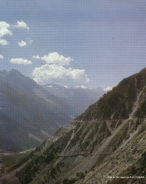
Zoji la - the approach to Ladakh
This region once formed part of the erstwhile
kingdom of Ladakh. In fact, it was the first to be inhabited by the early
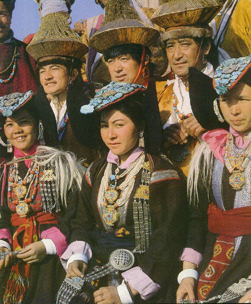
colonists of Ladakh - the Indo-Aryan Mons, the Dards of Central Asia and
itinerant Tibetans. Also, its valleys, by virtue of their proximity to
Kashmir, Kishtwar, Kulu and Gilgit-Baltistan served as the initial receptacle
of the cultural waves and ethnic movements that emanated from across the
Greater Himalayan wall. As the area receives abundant water from rivers
originating in the Greater Himalaya, the vegetation here is more luxuriant
than in eastern Ladakh. The upper Suru valley, in particular, is famous
for its extensive alpine grassland which attracts a large number of Bakarwal
herdsmen from the Jammu hills.
About 15,000 sq km in area, these valleys sustain
an agrarian population of approximately 70,000 people who cultivate the
fertile soil mainly available along the course of rivers. The majority
is Muslim (Shia faith), Islam having been introduced to them around the
middle of the 16th century by missionaries from Kashmir and Baltistan.
Their descendants, locally called Aghas, still hold sway, perpetuating
their faith in the teeth of ancient folk traditions which speak of a mixed
legacy of Buddhism and animism. Many folk traditions, particularly those
connected with various stages in the agricultural cycle, are still followed
by the people with subdued reverence.
The land approach to Ladakh is the 434 km Srinagar
- Leh highway (Kargil falls en route). For most of the way, this road follows
the traditional trade route between Srinagar and Leh, thus giving modern
travellers a glimpse of villages which are historically and culturally
important. The most dramatic part of the bus journey to Kargil is the ascent
up the Zojila or Zoji pass, the gateway to Kargil district.
Several outfitters based in India and abroad organize
long treks in the region. Mountaineering expeditions to Nun-Kun peaks are
catching on. Equally enthusiastic is the response of students with an interest
in social anthropology.
Kargil (2740m), 204 km from Srinagar, is the second
largest town of Ladakh. It is also the headquarters of our destination,
the district of Kargil. A quiet town today Kargil was once witness to the
most hectic bartering among traders of different faiths and nationalities.
Hundreds of caravans carrying silks, ivory, carpets and precious stones
to and from China, Turkey, Yarkand, Afghanistan and India, passed through
the town. Several caravanserais, now rendered dangerous due to years of
disuse, can be seen in and around Kargil. Substitute travellers for traders
and Kargil's position as a resting place remains unaltered. Tourists to
Leh by road make a night halt at Kargil before starting on the second leg
of the journey.
Kargil town lies in the lower Suru basin. Two
other rivers that meet here are Drass and Wakha Chu. Visible all around
are lush green fields of barley and wheat, vegetable beds and rows of poplars
and willows. Kargil is famous for its apricots and mulberries. June presents
a rare sight of fragrant white apricot blossoms while in August, the ripening
fruit lends the countryside an orange hue.
WHAT TO SEE
In Kargil, one can see some of the finest examples
of Turkish architecture. Day--long excursions can be taken to Mulbekh or
to the Suru valley to observe the grandeur of the Himalayan range from
close quarters. The evening can be spent profitably by walking along the
river. The ancient fort bridge across it gives a splendid view of the tiered
and terraced township sweeping down the hillside.
A stroll in the ancient bazaar might lead to a
shop selling attractive flint and tobacco pouches, travelling hookahs and
brass kettles - handcrafted items of everyday use which find their way
into the mart as curios. Pashmina shawls, cloth paintings using Buddhist
themes and symbols, and turquoise can be bought here at bargain prices.
And who knows, perchance, you may brush shoulders with one of the Minaros
(or Brokpas), a tribe that claims descent from the army of Alexander of
Macedonia.
EXCURSIONS
Situated 45 km east of Kargil on the road to Leh,
Mulbekh (3230m) is a typical Buddhist village. The village and the surrounding
valley take their name from a small watercourse which originates in the
Zanskar range and meets the Suru river at Kargil. Many monuments of the
early Buddhist era dot the landscape and are accessible from the village.
Mulbekh Chamba: The chief attraction of
Mulbekh is a 9-metre rock sculpture in deep relief of Maitreya, the Future
Buddha. Its execution combines esoteric Shaivite symbolism and early Buddhist
art. Situated bang on the highway, it dates back to the period when Kashmiri
Buddhist missionaries came travelling east of the Himalaya.
Mulbekh Gompa: Perched atop a rocky cliff,
the Mulbekh gompa (monastery) dominates the valley. It is easy to see why
in bygone times this site served as an outpost to guard the caravan route.
Like all monasteries it is adorned by frescoes and statues.
Shergole: This is a small village (5 km
short of Mulbekh) right of the Wakha brook on the Kargil-Leh road. Visible
from afar as a white speck against the brown granite, the monastery here
literally hangs out of a cliff.
Urgyan Rzong: This is a meditational retreat
tucked away behind an amazing natural mountain fortress. Concealed inside
is a green circular valley with a monastic establishment at its centre.
The hillsides reveal caves where high ranking Buddhist saints perform penance
in isolation. The only approach is a footpath laid through a narrow gap
in the rocky ramparts.
| 


No one has commented yet. Be the first!